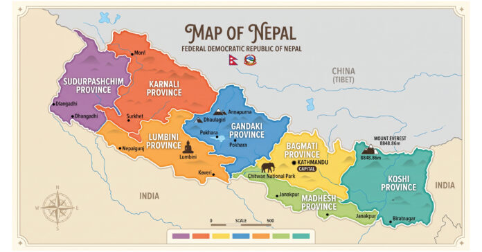
Nepal (officially the Federal Democratic Republic of Nepal) is a landlocked country situated along the southern slopes of the central Himalayas in South Asia. It borders the Tibet Autonomous Region of China to the north and India to the south, east, and west.
Key Country Facts
- Capital: Kathmandu
- Total Area: 147,516 km²
- Official Language: Nepali
- Currency: Nepalese Rupee (NPR)
- National Flag: The world’s only non-quadrilateral national flag, featuring two stacked triangular pennants.
- Highest Point: Mount Everest (Sagarmatha) at 8,848.86 m.
Geographic Regions
Nepal is divided into three parallel ecological belts extending from east to west:
- Himalayan Region (Mountain Belt): Located in the north, home to 8 of the world’s 14 peaks above 8,000 meters (including Everest, Kanchenjunga, Lhotse, Makalu, Cho Oyu, Dhaulagiri, Manaslu, and Annapurna).
- Hilly Region (Pahad): The central mountainous belt containing deep river valleys, including the Kathmandu and Pokhara valleys.
- Terai Region (Plains): The southern lowland strip along the border with India, known as the agricultural and industrial heartland of the country.
Administrative Structure: 7 Provinces & 77 Districts
Under the Constitution of 2015, Nepal transitioned into a federal republic comprising 7 Provinces, 77 Districts, and 753 Local Units (6 Metropolises, 11 Sub-Metropolises, 276 Municipalities, and 460 Rural Municipalities).
| Province | Capital | No. of Districts | Included Districts |
| Koshi Province | Biratnagar | 14 | Bhojpur, Dhankuta, Ilam, Jhapa, Khotang, Morang, Okhaldhunga, Panchthar, Sankhuwasabha, Solukhumbu, Sunsari, Taplejung, Terhathum, Udayapur |
| Madhesh Province | Janakpur | 8 | Bara, Dhanusha, Mahottari, Parsa, Rautahat, Saptari, Sarlahi, Siraha |
| Bagmati Province | Hetauda | 13 | Bhaktapur, Chitwan, Dhading, Dolakha, Kathmandu, Kavrepalanchok, Lalitpur, Makwanpur, Nuwakot, Ramechhap, Rasuwa, Sindhuli, Sindhupalchok |
| Gandaki Province | Pokhara | 11 | Baglung, Gorkha, Kaski, Lamjung, Manang, Mustang, Myagdi, Nawalpur (Nawalparasi East), Parbat, Syangja, Tanahun |
| Lumbini Province | Deukhuri (Dang) | 12 | Arghakhanchi, Banke, Bardiya, Dang, Gulmi, Kapilvastu, Parasi (Nawalparasi West), Palpa, Pyuthan, Rolpa, Rukum East, Rupandehi |
| Karnali Province | Birendranagar (Surkhet) | 10 | Dailekh, Dolpa, Humla, Jajarkot, Jumla, Kalikot, Mugu, Rukum West, Salyan, Surkhet |
| Sudurpashchim Province | Godawari (Kailali) | 9 | Achham, Baitadi, Bajhang, Bajura, Dadeldhura, Darchula, Doti, Kailali, Kanchanpur |
Culture, Economy, and Heritage
- Birthplace of the Buddha: Lumbini, situated in the Rupandehi district, is a designated UNESCO World Heritage Site and the birthplace of Siddhartha Gautama.
- Ethnic & Linguistic Diversity: Home to over 140 ethnic groups (such as Chhetri, Bahun, Magar, Tharu, Tamang, Newar, Rai, Gurung, and Sherpa) and more than 120 spoken languages.
- Economy: Heavily driven by services (tourism, hospitality), agriculture (rice, maize, tea), remittances from abroad, and rapidly growing hydropower generation.
